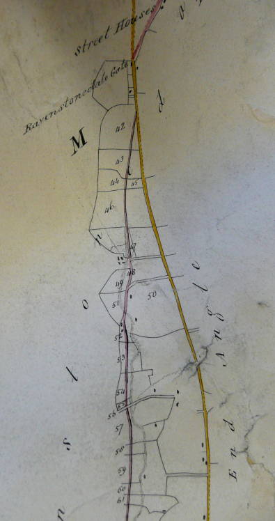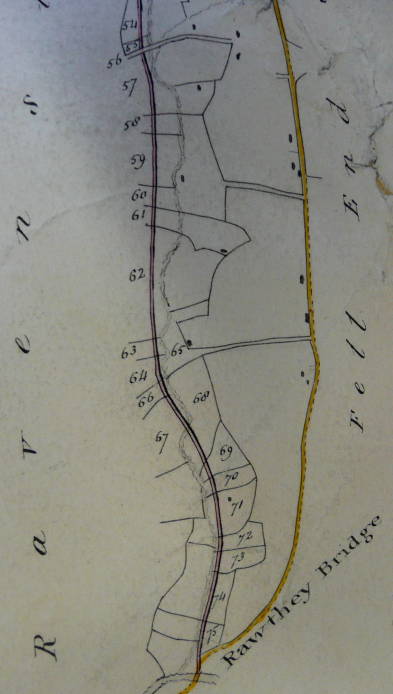

Sedbergh Turnpike Trust was set up in 1762 by Act of Parliament (2 Geo II) to build and maintain roads between Sedbergh and Kirkby Lonsdale, Kendal, Hawes and Kirkby Stephen, 62 miles of road in all.
The Marthwaite-Kirkby Stephen High Lane Head road followed the present A683, except for the section Rawthey Bridge (or Rathar Bridge) to the Ravenstonedale Toll Bar, which followed Street.
Toll gates were set up at intervals not too short to inconvenience traffic, but not too long to miss revenue. The average interval was five miles. The tolls were farmed out. The gatekeeper at Ravenstonedale Gate paid £25 p.a., and kept the tolls collected, except any receipts from the public stage 'if one be instituted' which he was to hand over to the Trustees. (Minute book, 1826) (The payment for the gate at Kirkby Stephen High Lane Head was £75 p.a. - obviously more lucrative)
The net revenue of Ravenstonedale Toll-Bar in 1813 was £53; in 1816 £65 and in 1825 £64/10s.
Tollkeepers were instructed to light the lamps at the Toll Bar between 1st October and 1st April from sunset to twelve o'clock at night.
In 1824, the Surveyor was asked to prepare plans for diversions of the road in Garsdale and towards Kirkby Stephen. He recommended that a better gradient could be achieved by leading the road along Buckbank Lane from Sedbergh to rejoin the existing road at Cross Keys, by making a new road from Rawthey Bridge to Ravenstonedale Toll Gate, and thence over Stennerskeugh Bridge to Wharton Hall.
The lower part of the diversion was not proceeded with, but at their meeting at the Black Bull, Sedbergh on October 7, 1825, the Trustees 'ordered that the new line of road from the north end of Rawthey Bridge to the Toll Bar in Ravenstonedale, and then by Stannerskew Bridge and Wharton Dykes to Kirkby Stephen be adopted.'
The necessary powers were conferred by Parliament in 1826 (7 Geo IV). The expense was to be "defrayed out of the Tolls, and not by Subscription."
A plan was drawn up, and the individual parcel numbers listed.

|
                       OWNER             OCCUPIER
40 Common or Waste Land
41   do.        do.
42 Field        Revd Allinson     Christopher Dixon
43   do.        Dr Tatham         John Brown
44   do.           do.                 do.
45   do.           do.                 do.
46   do.        Revd Richd Hunter Robert Johnson
47   do.           do.                 do.
48 Lane, Common or Waste Land
49 Field        Richard Holme     John Dawson
50   do.        Isaac Handley     Matthew Hunter
51 Field        Richard Holme     John Dawson
52   do.
53   do.
54   do.
55   do.
56   do.
57 Field        John Hunter       John Hunter
58   do.           do.                 do.
59 Field        Robert Hunter     Thos Thexton
60   do.           do.                 do.
61   do.           do.                 do.
62   do.           do.            Robert Hunter
63   do.           do.                 do.
64   do.        Isaac Handley     Robert Tunstall
65   do.        Wm Parker         Wm Parker
66 Lane, Common or Waste Land
67 Field        Isaac Handley     Robert Tunstall
68   do.        Wm Shaw           John Herd
69   do.           do.                 do.
70   do.        George Fawcett    George Fawcett
71   do.        Anthony Hunter    Anthony Hunter
72   do.           do.                 do.
73   do.        Ellen Alderson    Ellen Alderson
74   do.           do.                 do.
75   do.           do.                 do.
The costing for the section from "Rother Bridge" to Kirkby Stephen was: Forming, stoning and draining 598 rods @ 1/10 £ 897 0 0 Cop fencing 1196 rods @ 6/- 358 16 0 Forming, stoning and draining 2147 7 7 New stone fences 986 rods @ 12/- 591 12 0 Removing fences 192 rods @ 7/- 67 4 0 Cop fencing 450 rods @ 6/- 135 10 0 4 Under Gates across Road 70 0 0 21¼ Statute Acres @ £50 1062 10 0 | 
|
In 1830, land for further diversions in Ravenstonedale and Garsdale cost £2/7/4. The cost of labour was just over £700. (Account statement for 1830)
The Trust ran into financial difficulties with the coming of the railways, when some of the mortgagees who had lent it money demanded repayment, since their security (they had a charge on the tolls) was depreciating in value. Revd. Sedgwick of Dent caused the mortgagees' complaints to be formally entered in the Minute Book.
Turnpikes in England and Wales were abolished on November 1, 1874, and the roads vested in County Councils. The Sedbergh Trust sold off its properties (a shop in Sedbergh, the various toll houses - the one at Ravenstonedale was offered for sale at £50), and, there being no claims against it, the Trust was formally wound up on December 8, 1874.
(NB Photocopy of plan and section. The plan has several erasures, and the field parcel numbers have been rewritten several times to cope with different plans and projects - the smallest numbers were those of the original survey, the numbers in the series 52-86 added later, and the series 41-75 (in red) the final numbering. The plan and section both cover the entire road from Marthwaite to Kirkby Stephen at 4" to the mile. The section has embankments and cuttings for the diversion shaded in green and brown respectively)

The New and the Old
